Where is Arak?
Arak covers an area of about 107 square kilometers and has a population of approximately 520,000 people. It is the capital of Markazi Province and the largest city in the province. This province is bordered by Alborz Province to the north, Qazvin Province to the northwest, Hamadan Province to the west, Tehran Province to the northeast, Lorestan Province to the southwest, Isfahan Province to the southeast, and Qom Province to the east.The city of Arak is bordered by Tafresh to the north, Hamadan and Malayer to the west, Mahallat to the east, and Khomein and Shazand to the south. To the northeast, Arak connects to Tehran Province. If you look at the map of Iran, you will find Arak located in the central part of the country, slightly tilted towards the west. The city is approximately 280 kilometers southwest of Tehran.


Markazi Province is recognized as an industrial and economic hub of Iran. However, it is also the birthplace of prominent figures and great scholars such as the Naraghi scholars, Amir Kabir, Professor Hesabi, and many other notable religious, scientific, and cultural personalities throughout the country's history.With its illustrious history, Markazi Province has been a cradle for nurturing many scholars and elites in various fields and has always played a significant role in the realms of science, politics, and art. According to studies, the province has introduced over 56 religious scholars, 39 politicians, more than 70 scientists, 89 poets, and 50 distinguished artists to the nation and the world.


History of Arak
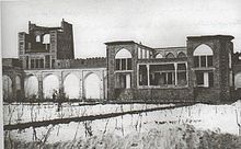
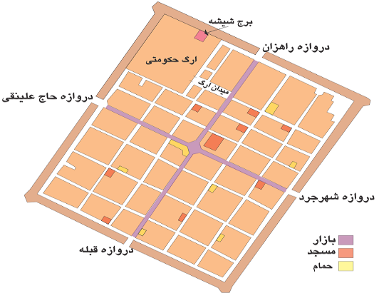
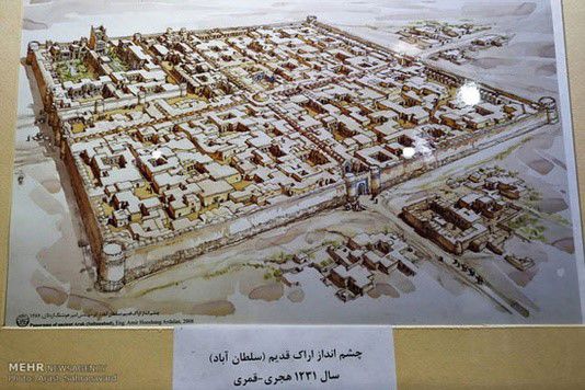
Before the establishment of the city in its current location, there were several villages in its vicinity. To the south of the city were Deh Qal'eh and Qal'eh Now, and to the west, Deh Hesar, which were demolished to make way for the construction of the new city. In the current location of the city, there was a village named "Dastgerdeh," remnants of which include a qanat (underground water channel) known as "Qanat Deh."Until 1938 (1317 in the Persian calendar), Arak was known as "Aragh," and before that, it was called "Sultanabad." The city's founder was Yusuf Khan Gorji, also known as Sepahdar of Iraq. According to historical accounts, before the city was established, the area contained eight or ten fortresses with names such as Khan Babakhan, Hisar, Deh Kohneh, Moradabad, Aqa Sami', Salim, Now, and Qader. The inhabitants of these fortresses were frequently in conflict with one another. Yusuf Khan reported the ongoing disputes to Fath-Ali Shah Qajar. The Shah ordered the destruction of the fortresses and the construction of a new city. At that time, two powerful tribes inhabited the region: the Khans of Farahan, who lived in what is now the Farahan district, and the Khans of Kazaz, who resided in today's Zalian district. Both tribes, upon learning about the plan to establish a new city (a military fortress), attempted to persuade the central government to construct the city in their respective territories but were ultimately unsuccessful. Yusuf Khan Gorji decided to build the city at its current location, which was the border between the territories of Farahan and Kazaz, to prevent disputes and conflicts. Having seen cities in Georgia and the Caucasus, Yusuf Khan aimed to design a well-organized and orderly city. He planned for all the streets to intersect at regular intervals, with each street measuring six cubits in width. The city's bazaar was strategically placed at its center to ensure easy access for all residents.